Dholera TP 2-B-1
Call / WhatsApp @9350473437 For Best Deal
Dholera TP 2-B-1 – Plots, Location, Amenities, Floor Plan & Sizes
Dholera TP 2-B-1 – Scheme Overview
It is a sub-scheme within Dholera Town Planning Scheme 2 (TP 2) in the wider Dholera Special Investment Region (Dholera SIR). Moreover, current planning references identify TP 2-B-1 as one of the TP 2 sub-schemes and associate it with parts of Dholera, Kadipur, Bhadiyad, Khun, and Bhimtalav.
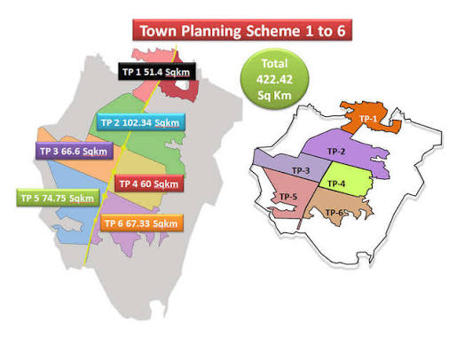
TP 2 forms part of Phase I of Dholera SIR. Furthermore, current planning references describe TP 2 as approximately 102.34 sq. km., making it the larger of the two major Phase-I town-planning schemes.
However, It does not represent one individual plotted development. Instead, it covers a planned area containing multiple survey parcels, Final Plots, roads, land-use zones, and infrastructure reservations. Therefore, buyers should verify the exact survey number, TP number, OP number, FP number, zoning, road alignment, and applicable development regulations before evaluating a property.
Key Highlights of Dholera TP 2-B-1
1. Strategic Dholera SIR Location
Dholera TP 2-B-1 sits within the wider Dholera SIR planning framework. Consequently, the area connects with Dholera’s broader urban, industrial, commercial, and infrastructure-development strategy.
2. Part of TP 2 Phase-I
TP 2 represents one of the major Phase-I town-planning areas. Additionally, TP 2 contains several sub-schemes, including TP 2-A, TP 2-B-1, TP 2-B-2, and TP 2-B-3.
3. Multiple Villages
Current references associate TP 2-B-1 with Dholera, Kadipur, Bhadiyad, Khun, and Bhimtalav. Therefore, the village name alone does not identify the exact TP status of a property. Buyers should always verify the survey number.
4. Planned Final Plots
Town Planning Schemes reorganize original land parcels into planned Final Plots. Moreover, the planning framework connects these plots with roads, utilities, public-purpose areas, and other infrastructure reservations.
5. Planned Road Connectivity
The TP 2 framework incorporates a substantial planned road network. As a result, road width, frontage, and access remain important factors when buyers evaluate individual plots. Current references estimate roughly 340 km of planned roads across TP 2, although a specific road may not yet have construction on the ground.
6. Property-Specific Zoning
Dholera SIR uses different land-use categories. Consequently, buyers should confirm whether a particular Final Plot permits residential, commercial, industrial, institutional, logistics, or another use.
Dholera TP 2-B-1 Amenities & Infrastructure
Dholera SIR follows a planned infrastructure model. However, the actual availability of a facility can vary according to the property’s location and development stage.
Planned Road Infrastructure
The TP framework integrates individual Final Plots with planned roads. Furthermore, buyers can review the applicable TP map to understand road alignment, frontage, and access.
Water & Drainage Infrastructure
The broader Dholera planning framework includes water and drainage infrastructure. Therefore, property pages should clearly distinguish between planned infrastructure and currently operational services.
Power Infrastructure
Dholera’s development framework incorporates power infrastructure for different development zones. Additionally, buyers should verify the actual electricity-service status for the individual property.
ICT & Smart Infrastructure
Dholera SIR follows a smart-city-oriented development model that incorporates information and communication infrastructure. Consequently, terms such as Dholera Smart City plots, Dholera SIR property, and Dholera infrastructure can support relevant SEO content.
Green & Open Spaces
Town Planning layouts can reserve land for open spaces, recreation, landscaping, and public purposes. Moreover, the exact location of these areas depends on the applicable TP and development plans.
Public & Community Infrastructure
Planned development can include land for public facilities and community infrastructure. Therefore, buyers should consult the relevant TP map before making claims about a particular amenity being immediately available near a property.
Dholera TP 2-B-1 Floor Plan
Understanding the TP 2-B-1 Layout
It does not have one standard residential floor plan. Instead, it represents a large town-planning sub-scheme containing multiple plots, roads, zones, and infrastructure reservations.
Therefore, a professional website should display the actual TP 2-B-1 map, OP-FP plan, location map, and property-specific plot layout instead of using a generic apartment floor plan.
Recommended Property Layout Details
| Property Detail | Information to Display |
|---|---|
| TP Scheme | TP 2-B-1 |
| Parent Scheme | TP 2 |
| Village | Verify exact village |
| Survey Number | Property-specific |
| Original Plot (OP) | Verify from records |
| Final Plot (FP) | Verify from applicable plan |
| Land-Use Zone | Verify from planning record |
| Plot Area | Actual documented area |
| Plot Dimensions | Actual measurements |
| Road Width | As per applicable plan |
| Road Facing | Property-specific |
| Corner Plot | Yes / No |
| Development Rules | Applicable regulations |
Furthermore, adding a Dholera TP 2-B-1 map, Final Plot map, survey-number information, road map, and location map can make the page more useful for property researchers.
Dholera TP 2-B-1 Plot Sizes
There is no single standard plot size for every property in TP 2-B-1. Instead, the size depends on the individual survey parcel, Final Plot, zoning, reconstitution plan, and project layout.
Therefore, publish only documented plot sizes on a specific property page.
| Plot Category | Plot Size | Potential Use |
|---|---|---|
| Residential Plot | Add verified size | Subject to zoning |
| Premium Residential Plot | Add verified size | Subject to zoning |
| Commercial Plot | Add verified size | Subject to permitted use |
| Road-Facing Plot | Add verified size | Subject to zoning |
| Corner Plot | Add verified size | Subject to approved layout |
| Custom Plot | Add verified size | Verify documents |
Moreover, avoid publishing fixed figures such as 1,000 sq. ft., 1,500 sq. ft., 2,000 sq. ft., 250 sq. yd., or 500 sq. yd. unless your actual property documents confirm those sizes.
Dholera TP 2-B-1 Land-Use & Development
Dholera SIR accommodates multiple development categories. Consequently, the permitted use of an individual TP 2-B-1 property depends on its designated zoning.
For example, a property may fall within a residential, commercial, industrial, institutional, logistics, or other planning category. Therefore, buyers should check the applicable land-use map and development regulations before making assumptions about construction or property use.
Additionally, the Final Plot number and survey number provide important references for property verification.
Why Explore Dholera TP 2-B-1?
Dholera TP 2-B-1 attracts attention because it forms part of the broader Dholera SIR Phase-I planning framework. Furthermore, TP 2 includes a large planned area with multiple sub-schemes and infrastructure corridors.
Consequently, people researching Dholera plots, Dholera SIR plots, Dholera Smart City plots, Dholera property, Dholera land, and Dholera real estate can use TP 2-B-1 as an important planning reference.
However, buyers should evaluate each property individually rather than treating the entire TP 2-B-1 area as one development project.
TP 2-B-1 Property Verification Checklist
Before purchasing or advertising a property, verify:
- Survey number
- Village name
- TP scheme
- Sub-scheme
- Original Plot (OP)
- Final Plot (FP)
- Land-use zoning
- Road width
- Road access
- Plot dimensions
- Plot area
- Title documents
- Revenue records
- Applicable development permissions
- Current infrastructure status
SQUARE METERS Realtors Pvt. Ltd.
- Deals You Deserve -
Office: BA-12, Main Road, Ansal Golf Link 1, Omega 1, Greater Noida
For resale queries, whatsapp/ call us @ 9350473437