Dholera Panchi
Call / WhatsApp @9350473437 For Best Deal
Dholera Panchi – Scheme Overview, Key Highlights, Amenities, Floor Plan & Sizes
Dholera Panchi Overview
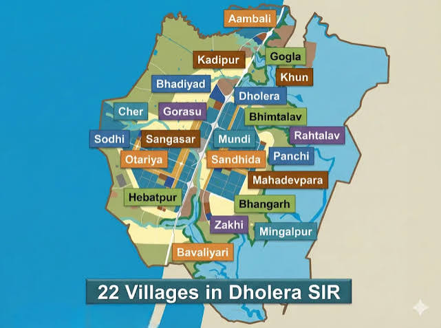
It is a revenue village located within the broader Dholera Special Investment Region (Dholera SIR) in Gujarat. Panchi covers approximately 13.96 sq. km. and appears in the planning records associated with the Dholera development area. Current planning sources connect different portions of Panchi with multiple Town Planning schemes; therefore, the applicable scheme should always be checked using the property’s exact survey number.
Furthermore, Panchi is included in the town-planning framework through which land parcels can be reorganized into roads, final plots, infrastructure areas, public facilities and other designated uses. Consequently, Panchi Dholera property, Dholera SIR land, and Dholera plots are relevant search terms for people researching the region.
Importantly, the village name alone does not determine the development rights of a particular parcel. Instead, buyers should verify the survey number, applicable TP scheme, land-use zone, Final Plot details and current government records.
Dholera Panchi Key Highlights
1. Location in Dholera SIR
Panchi forms part of the wider Dholera SIR region. As a result, it is frequently included in searches for Dholera SIR property, Dholera Gujarat real estate, and Dholera land for sale.
2. Planned Town-Planning Framework
The Dholera planning system uses Town Planning schemes to organize existing land parcels into a structured development pattern. Moreover, TP maps identify original plots, final plots, roads, public-use areas and infrastructure reservations.
3. Multiple TP References
Panchi requires parcel-level verification because different planning references associate the village with different TP records. For example, a current TP 4-A reference identifies Panchi and Bawaliyari, while the TP 4/B-1 map explicitly lists Panchi among its five part villages.
4. Planned Road Network
The available TP documentation shows planned roads and infrastructure corridors around the scheme area. Therefore, road access should be evaluated from the relevant TP map rather than assumed from the village location.
5. Diverse Land-Use Planning
The wider Dholera planning framework includes residential, commercial, industrial, knowledge and IT, logistics, recreation, public facilities and other land-use categories. However, the permitted use of an individual Panchi parcel depends on its applicable zoning and planning record.
6. Central Dholera SIR Location
Panchi is located among other Dholera SIR villages, including Mundi and Sandhida. Consequently, its location is relevant to people researching land within the interior parts of the planned development region.
Dholera Panchi Amenities & Infrastructure
Panchi should not be described as a conventional gated residential project with a fixed developer-provided amenity package. Instead, its infrastructure should be understood through the Dholera SIR and Town Planning framework.
Relevant planned infrastructure categories include:
- Planned road network
- TP and DP roads
- Green and open-space areas
- Social infrastructure
- Physical infrastructure
- Utility corridors
- Residential-use areas
- Commercial-use areas
- Industrial-use areas
- Public facilities
- Knowledge and IT zones
- Logistics-related zones
For example, the available TP 4/B-1 plan identifies DP/TP roads, open green space, social infrastructure, physical infrastructure, residential sale areas, commercial sale areas and industrial sale areas.
Therefore, the exact amenities available to a property should be confirmed from the relevant TP layout and on-ground development status.
Dholera Panchi Floor Plan / Layout
Dholera Panchi does not have a conventional apartment or villa floor plan because it is a revenue village and planning area rather than one residential project.
Instead, the relevant planning document is the Town Planning Scheme layout / Original Plot–Final Plot (OP-FP) map.
The planning structure can be represented as:
Revenue Survey Number → Original Plot (OP) → Town Planning Scheme → Roads & Reservations → Final Plot (FP)
Accordingly, a Panchi property layout should be reviewed for:
- Survey number
- Original Plot number
- Final Plot number, where applicable
- Plot boundaries
- Road width
- Road reservations
- Adjacent land use
- Green-space reservations
- Social infrastructure
- Physical infrastructure
- Applicable development regulations
The available TP 4/B-1 OP-FP map specifically identifies Panchi as one of the part villages and shows original and final plot boundaries together with roads and designated land-use areas.
Dholera Panchi Sizes
There is no single standard residential plot size for the whole of Panchi.
The 2009 government notification records Panchi with an area of approximately 13.9638 sq. km. and 360 survey numbers. These figures refer to the notified revenue-village area and survey records; they should not be confused with individual residential or commercial plot sizes.
For a property website, it is therefore better to publish the exact documented size for each individual listing.
Recommended Property Size Format
| Property Detail | Website Information |
|---|---|
| Village | Panchi, Dholera SIR |
| Survey Number | Mention exact survey number |
| Land Area | Mention documented area |
| TP Scheme | Verify parcel-specific scheme |
| Final Plot | Mention FP number where officially available |
| Road Width | Verify from current TP/DP map |
| Land Use | Verify current zoning |
| Property Type | Agricultural / Residential / Commercial / Industrial, as applicable |
This approach provides more accurate information than publishing one generic plot-size range for the entire village.
Dholera Panchi Property Research
Panchi is relevant to searches for Dholera SIR land investment, Dholera plots for sale, Dholera land for sale, and Dholera property investment. Furthermore, its inclusion in the Dholera planning framework makes survey-level planning information especially important.
However, buyers should not rely only on a brochure or village name. Instead, they should compare the property documents with current revenue records and applicable DSIRDA planning documents.
Important Verification Before Buying
Before purchasing land in Dholera Panchi, verify:
- Survey number
- Ownership and title documents
- Latest revenue records
- Applicable TP scheme
- TP scheme stage
- Original Plot details
- Final Plot details, where applicable
- Current land-use zoning
- Road reservations
- Development permissions
- NA/conversion status, where applicable
- Current government records
Most importantly, being located inside Dholera SIR does not automatically mean that every parcel is construction-ready or has the same permitted land use.
SQUARE METERS Realtors Pvt. Ltd.
- Deals You Deserve -
Office: BA-12, Main Road, Ansal Golf Link 1, Omega 1, Greater Noida
For resale queries, whatsapp/ call us @ 9350473437