Dholera Mahadevpura
Call / WhatsApp @9350473437 For Best Deal
Dholera Mahadevpura – Dholera SIR Property, TP Scheme & Land Guide
Dholera Mahadevpura Scheme Overview
It is one of the revenue villages associated with the Dholera Special Investment Region (Dholera SIR), Gujarat. The village covers approximately 22.54 sq. km., with a current land-record reference identifying around 179 survey numbers.
Moreover, current planning references associate Mahadevpura with TP 6-A, alongside Jankhi. The available TP 6-A reference describes it as a Phase-2 draft Town Planning Scheme, with notification shown as pending.
However, another current village-level planning source identifies Mahadevpura in relation to TP4 and notes that the village touches the boundary of the Activation Area. Therefore, buyers and property researchers should check the exact survey number, applicable TP drawing, zoning and current official records instead of assuming that every parcel follows the same TP designation.
Consequently, Mahadevpura is an important location for people researching Dholera SIR land, Dholera plots, Dholera TP schemes and future planned development.
Dholera Mahadevpura Key Highlights
- Located within the Dholera Special Investment Region
- Approximately 22.54 sq. km. village area
- Around 179 survey numbers according to a 2026 land-record reference
- Current planning references associate the village with TP 6-A
- TP 6-A includes Jankhi and Mahadevpura
- TP 6-A is described in current planning material as a Phase-2 draft scheme
- Another village-level source associates Mahadevpura with TP4, demonstrating why parcel-level verification matters
- The broader Dholera planning framework includes residential, industrial, logistics, knowledge, recreation, tourism and infrastructure zones
- Land-use classification depends on the individual survey number
- Original Plot and Final Plot information should be checked where applicable
- The village is relevant to research around Dholera SIR property and land parcels
- Current physical development can differ significantly from the wider Dholera master plan
Furthermore, Dholera SIR covers a much larger planned region of approximately 920 sq. km., divided into multiple Town Planning schemes. The more developed Activation Area is concentrated within TP2, so being located inside Dholera SIR does not automatically mean that a particular parcel has operational urban infrastructure.
Dholera Mahadevpura Location Advantage
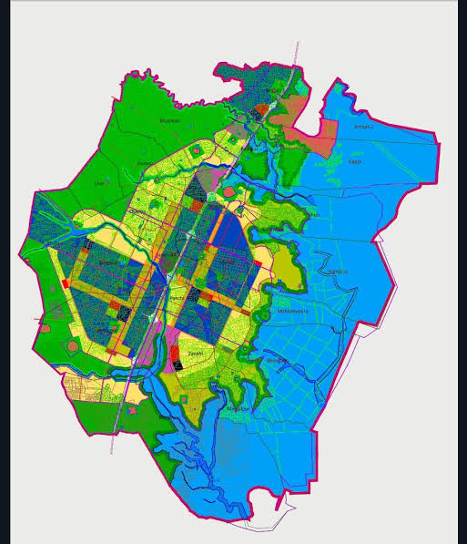
Mahadevpura forms part of the wider Dholera SIR master-planning area. Therefore, its location should be evaluated not only by present-day village surroundings but also by the applicable TP plan and future land-use framework.
In addition, the village-level planning information indicates that Mahadevpura has a relationship with the broader planned development and Activation Area boundary. However, touching or being near a planned development zone does not mean that an individual property automatically falls inside that zone.
Important location factors include:
- Dholera SIR boundary
- Applicable Town Planning scheme
- Survey-number location
- Proposed road network
- Final Plot status
- Land-use classification
- Distance from developed infrastructure
- Nearby planned economic zones
- Current physical access to the property
Thus, a proper location assessment should combine the village map, TP map and revenue records.
Dholera Mahadevpura Amenities & Infrastructure
Mahadevpura should be presented as a planned-region village, rather than as a conventional private residential project with ready-made builder amenities.
Nevertheless, the Dholera SIR planning framework provides for several categories of future and planned infrastructure.
Planned Road Connectivity
Town Planning schemes provide planned road corridors and access networks. Accordingly, the actual road width and frontage for a specific parcel should be confirmed from its applicable TP plan.
Utility Infrastructure
The wider Dholera SIR framework incorporates provisions for utilities and infrastructure corridors. However, actual utility availability can vary according to the location and development stage.
Green & Open Areas
Planning zones can include green spaces, ecological buffers, recreation areas and other reserved land. In particular, the TP 6-A planning reference identifies green space among its dominant zones.
Recreation & Tourism Planning
TP 6-A currently identifies Tourism & Resorts and Recreation, Sports & Entertainment among its dominant planned zones. Therefore, these categories can be relevant when studying parcels within the applicable TP area.
Residential & Commercial Planning
The broader TP 6-A zoning framework includes residential and city-centre categories, along with industrial, knowledge, logistics and high-access-corridor zones. Nevertheless, the permitted use of an individual Mahadevpura parcel depends on its exact survey number and zoning.
Important: Planned amenities should not be described as operational facilities unless their current on-ground status has been independently verified.
Dholera Mahadevpura Floor Plan & Layout
There is no conventional apartment-style floor plan for Mahadevpura because it is a revenue village rather than a single residential project.
Instead, the relevant document is the Dholera Town Planning layout/map.
A TP layout can show:
- Original Plot (OP)
- Final Plot (FP)
- Survey boundaries
- Proposed roads
- Land-use zones
- Public-purpose reservations
- Green areas
- Utility corridors
- Infrastructure reservations
- Reconstituted parcels
Therefore, anyone listing a specific Mahadevpura property should ideally provide the survey number and applicable TP/OP-FP map.
The current TP 6-A planning reference lists Mahadevpura and Jankhi as the villages within the scheme and identifies multiple land-use categories. However, the source also describes TP 6-A as draft/pending, so the latest authoritative planning record should be checked before publishing a parcel as having a confirmed final designation.
Dholera Mahadevpura Plot & Land Sizes
Mahadevpura does not have one standard residential plot size.
Instead, land parcels are identified through revenue survey numbers, and their areas can vary considerably. A current village-level record reports approximately 22.5431 sq. km. for the village and 179 survey numbers.
For accurate property listings, use the following format:
| Property Detail | Information |
|---|---|
| Village | Mahadevpura |
| Region | Dholera SIR, Gujarat |
| Village Area | Approx. 22.54 sq. km. |
| Survey Numbers | Approx. 179 |
| TP Scheme | Verify survey-wise |
| Original Plot | Verify from applicable TP record |
| Final Plot | Verify where applicable |
| Plot Size | As per verified revenue/TP record |
| Land Use | Survey-number specific |
| Road Width | Verify from applicable TP map |
| Ownership | Verify from current revenue records |
Accordingly, it is better to publish the actual documented parcel size rather than advertise a generic “Mahadevpura plot size.”
Dholera Mahadevpura Land Use
Land use is one of the most important factors when researching property in Mahadevpura.
Current TP 6-A planning material lists categories including:
- Residential
- City Center
- Industrial
- Knowledge & IT
- Logistics
- High Access Corridor
- Recreation, Sports & Entertainment
- Tourism & Resorts
- Solar Park
- Strategic Infrastructure
- Green Space
However, these are planning categories for the applicable TP area, not a statement that every Mahadevpura survey number has each of these uses.
Therefore, before publishing or purchasing a particular property, verify:
- Survey number
- Current 7/12 revenue record
- Applicable TP scheme
- Original Plot details
- Final Plot details
- Land-use zone
- Road reservation
- Public-purpose reservation
- Current planning status
- Applicable development permissions
Dholera Mahadevpura Property Research
Mahadevpura can be relevant for people researching the wider Dholera SIR property market. Furthermore, its connection with planned Town Planning schemes makes the village different from an ordinary rural land market.
However, property analysis should remain parcel-specific.
For example, two properties within the same revenue village can have different:
- Survey numbers
- Land-use classifications
- Road access
- TP status
- Final Plot details
- Reservations
- Development permissions
Consequently, the village name alone should never be treated as sufficient proof of a property’s development potential.
SQUARE METERS Realtors Pvt. Ltd.
- Deals You Deserve -
Office: BA-12, Main Road, Ansal Golf Link 1, Omega 1, Greater Noida
For resale queries, whatsapp/ call us @ 9350473437