Dholera TP 5-B
Call / WhatsApp @9350473437 For Best Deal
Dholera TP 5-B – Town Planning Scheme, Map, Plots & Land Guide
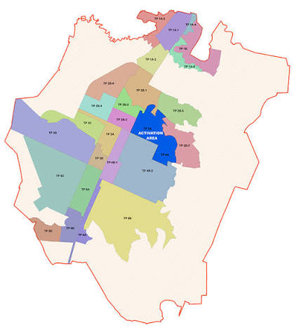
Dholera TP 5-B Scheme Overview
It is a Town Planning Scheme located within the larger Dholera Special Investment Region (Dholera SIR), Gujarat. It forms part of the broader TP 5 planning framework and is relevant for people researching Dholera SIR plots, Dholera land, TP maps, Final Plots and planned infrastructure.
Current planning information identifies Mundi and Ambali as the two villages associated with TP 5-B. Furthermore, the available TP 5-B split document records approximately 955 hectares, or 9.55 sq. km., for TP 5-B.
Importantly, current planning information describes TP 5-B as a Draft, Phase-2 scheme, with notification shown as pending. Therefore, website content should distinguish between the proposed planning framework and infrastructure that is already operational on the ground.
Moreover, a Town Planning Scheme reorganizes existing revenue parcels into a planned framework containing roads, Final Plots, public-purpose reservations, infrastructure corridors and different land-use zones. Consequently, the exact status of an individual property must be checked against its survey number and applicable planning records.
Dholera TP 5-B Key Highlights
- Located within Dholera SIR, Gujarat
- Part of the broader Dholera TP 5 planning framework
- Associated with Mundi and Ambali
- Approximate TP 5-B area: 955 hectares
- Equivalent area: approximately 9.55 sq. km.
- Current planning reference: Draft
- Planning phase: Phase-2
- Current notification status shown as pending
- Includes Original Plot and Final Plot planning
- Planned road infrastructure forms part of the TP layout
- Multiple land-use categories are identified within the planning framework
- Solar Park is listed among the dominant planned zones
- Industrial development is another important planned land-use category
- High Access Corridor planning is also identified
- Residential, commercial, logistics and public-facility categories appear in the wider zoning framework
- Exact land use depends on the individual parcel and applicable planning record
Additionally, the available TP 5-B OP-FP split document shows TP 5-B at 955 hectares, while the remaining portions of the broader TP 5 framework are separately identified as TP 5-A, TP 5-C-1 and TP 5-C-2.
Dholera TP 5-B Location
TP 5-B forms part of the planned Dholera SIR region. Specifically, current planning information identifies Mundi and Ambali as its associated villages.
Therefore, the location should be understood at several levels:
Dholera SIR Level
The property lies within the larger Dholera Special Investment Region planning framework.
TP 5-B Level
The parcel must fall within the mapped TP 5-B boundary to be described specifically as a TP 5-B property.
Survey Number Level
Finally, the exact survey number should be matched with the applicable Original Plot, Final Plot and land-use information.
Consequently, simply having a Mundi or Ambali address does not by itself establish that a particular parcel belongs to TP 5-B.
Dholera TP 5-B Amenities & Infrastructure
Dholera TP 5-B is a Town Planning Scheme rather than a private residential township. Therefore, its amenities should be described as planned infrastructure and land-use provisions instead of builder-provided facilities.
Planned Road Network
The TP planning framework provides for proposed road corridors and access routes. Furthermore, the OP-FP planning structure identifies proposed DP/TP roads and other road infrastructure.
However, the actual road width and construction status should be verified for the specific Final Plot.
Solar Park Infrastructure
Solar Park is identified as one of the dominant zones in TP 5-B. Consequently, solar-generation and associated infrastructure form an important component of the planning framework.
Industrial Development
Industrial land use is also identified within TP 5-B. Moreover, the planning framework describes industrial areas in connection with manufacturing, warehousing and ancillary activities.
High Access Corridor
A High Access Corridor is another dominant planning category. Such areas can support mixed-use frontages along major planned transportation corridors. Nevertheless, the permitted development on a specific parcel depends on its actual zoning and applicable regulations.
Residential & City-Centre Zones
The broader TP 5-B zoning framework also lists Residential and City Center categories. Therefore, land-use verification is particularly important before marketing a particular parcel as residential or commercial property.
Logistics & Public Facilities
Additionally, the planning framework includes Logistic and Public Facilities categories. These provisions support the wider planned urban and economic structure of Dholera SIR.
Important: Planned infrastructure should not automatically be described as an operational amenity. Instead, current site conditions should be verified before making a property-specific claim.
Dholera TP 5-B Floor Plan & Layout
Because TP 5-B is a Town Planning Scheme, it does not have a conventional apartment floor plan.
Instead, the appropriate document is the TP 5-B OP-FP Map and Town Planning Layout.
The layout can identify:
- Original Plot (OP)
- Final Plot (FP)
- Revenue survey numbers
- TP scheme boundary
- Village boundaries
- Proposed DP/TP roads
- Existing roads
- Water bodies
- Green spaces
- Social infrastructure
- Physical infrastructure
- Public-purpose areas
- Residential plots
- Commercial plots
- Tourism-related plots
- Other planned land-use categories
The available TP 5-B planning document specifically uses an OP-FP framework and identifies roads, infrastructure, green space and saleable land-use categories in its legend.
Therefore, for a website, the preferred heading is:
“Dholera TP 5-B OP-FP Map & Town Planning Layout”
rather than “Dholera TP 5-B Apartment Floor Plan.”
Dholera TP 5-B Sizes & Area
The documented scheme-level area for TP 5-B is approximately:
| Particular | Details |
|---|---|
| TP Scheme | TP 5-B |
| Region | Dholera SIR, Gujarat |
| Associated Villages | Mundi and Ambali |
| Approx. Scheme Area | 955 hectares |
| Approx. Area | 9.55 sq. km. |
| Planning Stage | Draft |
| Development Phase | Phase-2 |
| Notification | Pending, according to current planning reference |
| Plot Structure | Original Plot / Final Plot |
| Individual Plot Size | Varies by parcel |
| Land Use | Survey/FP specific |
The 9.55 sq. km. figure represents the overall TP 5-B scheme area; it does not mean that individual plots have a standard 9.55 sq. km. size.
Similarly, individual residential, commercial, industrial or other parcels can have different dimensions. Therefore, property listings should use the verified area from the relevant revenue and TP records.
Dholera TP 5-B Land Use
Current planning information identifies several land-use categories in TP 5-B, including:
- Residential
- City Center
- Industrial
- Knowledge & IT
- Logistics
- High Access Corridor
- Recreation, Sports & Entertainment
- Tourism & Resorts
- Solar Park
- Strategic Infrastructure
- Public Facilities
- Agriculture
- Green Space
- Village Buffer
However, these categories represent the planning framework and should not be interpreted as meaning that every parcel contains all of these uses.
Instead, the exact survey number should be checked to determine:
- Applicable TP scheme
- Original Plot number
- Final Plot number
- Land-use zone
- Road reservation
- Public-purpose reservation
- Plot area
- Development regulations
- Current planning status
- Applicable permissions
As a result, survey-level due diligence remains essential for Dholera TP 5-B property.
Dholera TP 5-B Mundi & Ambali
Mundi
Mundi is identified as one of the villages associated with TP 5-B in current planning information. Therefore, properties within Mundi should be checked against the TP 5-B boundary before being marketed specifically under this scheme.
Ambali
Ambali is the second village identified within the current TP 5-B planning reference. Consequently, survey-level verification is equally important for land located in Ambali.
Dholera TP 5-B Property Research
Dholera TP 5-B can be relevant to people researching Dholera SIR property, Dholera land for sale, Dholera plots and future planned development.
Furthermore, the combination of industrial, solar, high-access and other planned zones gives the scheme a diverse planning profile. However, the draft status means that current planning information should be checked before making definitive claims about a particular parcel.
Moreover, the property’s location within the TP boundary is only one part of the due-diligence process. Ownership, survey records, land use, road access, Final Plot details and applicable permissions should also be examined.
SQUARE METERS Realtors Pvt. Ltd.
- Deals You Deserve -
Office: BA-12, Main Road, Ansal Golf Link 1, Omega 1, Greater Noida
For resale queries, whatsapp/ call us @ 9350473437